Tent Rings, Caches & Cairns
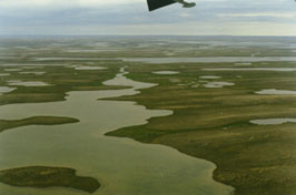
AERIAL VIEW OF KING WILLIAM ISLAND TERRAIN |
The northwest coast of King William Island, bordering Erebus Bay, presents a stark landscape of broken limestone and low gravel ridges that create little relief from the island's flat topography. The limestone base of King William was formed 300 million years ago. Since glaciation disappeared some five thousand years ago King William Island has slowly risen from the surrounding sea (referred to as isostatic rebound). Inland relict beach ridges depict where the sea coast once washed up gravel onto the land with the ice and ocean waters. The melting glaciers also created eskers - winding ridges of gravel deposited in melt channels under the glaciers.
Only the rare caribou or evidence of musk-ox is seen here as there are no extensive vegetated valleys to attract these grazers. Similarly, Erebus Bay is shallow and would not be as attractive to seals as would deeper bays found to the north and south. Yet even further afield there are no lakes or rivers that are habitat to fish, such as char. Therefore, the west coast of King William Island has generally been considered a desolate place that was seldom visited by Inuit, as the hunting here was considered poor. As one travels around the west coast and along the south coast of King William, the number of caribou, geese, ducks and even sea mammals increases noticably.
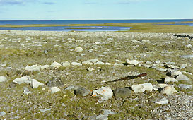
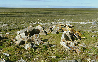
TENT RING |
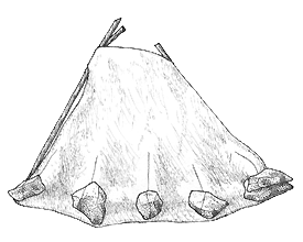
In the past four years over one hundred indigenous sites have been found due to our explorations of western King William Island. Almost all of these sites consist of one or more tent rings; some sites having as many as ten tent rings. The rings represent where individuals, families or more than one family, had located their tents for varied lengths of time. The stone rings represent where the edges of the tent skin walls were weighted down with rocks. Some tent rings have two circles of stones usually with a well defined ring inside another ring of fewer rocks. The outside stones likely anchored sinew which helped stabilize the tent walls in strong winds.
Tent rings are often divided into two main areas by a mid-line of stones. The mid-line separates the activity area from the sleeping area. Within the activity area can be found the hearth or cooking alcove, as well as storage alcoves. The sleeping area often consists of a smooth surface of fine gravel contrasting with the rough surfaces of the activity area. Some tent rings have exterior hearths and storage alcoves.
 |
 |
The rings date as old as 800 to 1000 years and up to recent times. The manner in which the tent rings are constructed and where they are located relative to the coastline give clues as to how old they are. One site of note consists of a semi-subterranean stone foundation house with an intact entrance tunnel. This house was dug into the gravel ridge then lined with large flat rock. The entrance tunnel, also made of large flat rock, was roofed with stone lintels. This site could possibly represent an early Thule presence on the island. None of the sites found on western King William pre-dates Thule (i.e., no Dorset or pre-Dorset sites).
DATE
(years before present) |
CULTURE |
| 4000 - 3500 BP |
Independence |
| 3500 - 2500 BP |
Pre-Dorset |
| 2500 - 1000 BP |
Dorset |
| 1000 - present |
Thule - Inuit |
|
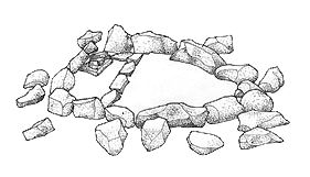
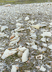
OLDER TENT RING, POSSIBLY PREHISTORIC.
NOTE THE LARGER ROCKS, COVERED IN ORANGE LICHEN. |
|
BOAT SHELTER |
Most of the sites date to the prehistoric although numerous later sites are contemporary to Franklin as indicated by the presence of European objects. Also, tent rings of the Franklin period tend to be constructed of similar size boulders tightly packed and often double walled. Yet again, several sites have been found which indicate that Inuit have occasionally hunted here even in the past fifty years. The tent walls of more modern Inuit are constructed of rocks of various sizes and shapes and are widely dispersed. The documentation of prehistoric and historic Inuit sites gives clues as to the available resources which sustained these people and how the Inuit are able to exploit these resources in what appears to be a barren landscape.
Other stone structures represent caches, fox traps, cairns and boat (e.g., kayak and umiak) shelters. Of particular interest is a pattern of flat stones that may have been a Nangissat, a jumping game. Several large caches revealed intact interior storage spaces. These caches were usually found on high ridges. Caches were used to store gear that was not required during a season, such as storing winter clothes, hunting tools and heavy skins during the summer when one wants to travel light. Other caches may have stored meats where heavy rocks were used to prevent thievery by animals.
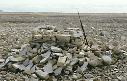
STONE CAIRN |
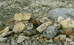
CACHE |
Text, drawings and photos copyright © 2002, John D. A. MacDonald.
|
|